
Διαβάστε το άρθρο στα ελληνικά.
Greece Dropped the Survey Plan From Deeds: What a Buyer Must Now Check
On this page
The April 2026 exemption is narrower than the headlines, and it moves the boundary check onto the buyer.
This guide is a preliminary screen for a cost or timing question, not legal, surveying, engineering or tax advice; read the full scope and limits before relying on it.
Have a specific plot in mind? Every check in this guide can be run on it, with source and date, for EUR 29 total · VAT included. Pin it on the map →
On 7 April 2026 Greece stopped requiring a survey plan on the deed for one defined class of property transfers. The headlines read like an abolition. The provision is narrower than that, and for most of the land a foreign buyer looks at, it changes nothing. What it does change is who is left checking the boundary, and the answer is now the buyer. Read this beside the guide to the survey plan itself and the guide to a deed that disagrees with the cadastre.
Everything below cites the statute as published and names the register that answers each question. Where the record does not settle a point, the gap is written down as a gap.
What άρθρο 16 actually says
Ν. 5293/2026, published in ΦΕΚ Α΄ 57 on 7 April 2026, is a wide administrative statute. Its άρθρο 16 amends άρθρο 5 παρ. 1 ν. 651/1977, the provision that had made the τοπογραφικό διάγραμμα a compulsory attachment to a deed. The new sentence reads: “Δεν απαιτείται να επισυναφθεί το τοπογραφικό διάγραμμα της παρούσας σε δικαιοπραξίες με αντικείμενο τη μεταβίβαση ακινήτου που βρίσκεται σε περιοχή στην οποία υφίσταται λειτουργούν Κτηματολόγιο, εφόσον στην περιοχή αυτή έχει κυρωθεί και μεταγραφεί πράξη εφαρμογής”.
Read the sentence slowly and it carries three conditions, joined by “εφόσον”. The property has to sit in an area with an operating cadastre. That same area has to have an implementation act that was ratified and then registered. And the transaction has to leave the limits of what is being sold where they already are. Take away any one of the three and άρθρο 5 παρ. 1 applies in its old form, with the plan attached as before.
The second condition is the one that decides most cases
A πράξη εφαρμογής is not a cadastral document at all. It belongs to ν. 1337/1983, and it is the instrument by which a street plan is put into effect on the ground: it fixes what each owner surrenders as εισφορά σε γη, what is owed as εισφορά σε χρήμα, and where the new plots and roads finally sit. It exists where a plan has been implemented. Out of plan there is no street plan to implement, so there is no implementation act, so the exemption cannot reach the transfer. Older in-plan neighbourhoods, laid out long before 1983, can be in the same position for a different reason.
That single point turns a headline into a much smaller rule. A flat in a post-1983 extension of a mainland town may well qualify. A hillside plot above a village on Samos, a coastal field in Messenia, an olive grove outside a settlement boundary: these are the properties that fill a foreign buyer's shortlist, and none of them has an implementation act to point at. The notary will ask for the plan exactly as before.
| Question | Who answers it | With which document |
|---|---|---|
| Does the exemption reach my transfer? | The notary | The phase check and the implementation act for the area |
| Where does the boundary run on the ground? | The surveying engineer | A measured plan in ΕΓΣΑ 87, signed |
| Does the title match the cadastral sheet? | The lawyer | A title search and the cadastral extract |
| Is the structure on the land lawful? | The civil engineer | The permit, the building identity file and any legalisation dossier |
Source: the division of roles that follows from άρθρο 16 ν. 5293/2026, ν. 4409/2016 and the transfer procedure described on gov.gr. Checked 16 August 2026.
What the amendment did not touch
Several duties survive untouched, and each has its own statute. Since 16 July 2018, ν. 4409/2016 άρθρο 40 has required a surveying engineer to file every new survey plan electronically in the Hellenic Cadastre's database. Where a registrable act uses a plan drawn on or after that date, the notary must obtain the filing receipt and attach it, and the statute attaches nullity to the failure. Nothing in ν. 5293/2026 relieves that. It only removes the obligation to have a plan in the first place, in the narrow case described above.
The building file is a separate track again. Where a structure stands on the land, its permit and its Ηλεκτρονική Ταυτότητα Κτιρίου come with drawings of their own, and the engineer who completes that file works from measurements. So do the forest extract, the coastal demarcation and any planning certificate. A buyer who reads “no survey plan required” as “no measurement required” is going to meet a surveyor later, at a worse moment and usually at a higher price.
Why the surveying profession objected
The associations of διπλωματούχοι αγρονόμοι τοπογράφοι μηχανικοί came out against the provision in January 2026, and their argument is worth reading even by someone who thinks the simplification is overdue. Their case was not that the cadastre is unreliable in principle. It was that the completed cadastre still carries errors of several kinds, and that the survey plan attached to a deed was the one moment in a transaction when a licensed engineer compared the registered geometry with the ground and signed for the comparison. Remove the moment and the error simply passes to the next owner.
They listed the failures they meet in practice: coordinates carried across from a local system or from ΤΜ3° into ΕΓΣΑ 87 with a systematic shift; a building whose side distances or building line are wrong inside a boundary that is itself correct; an obligation under ν. 1337/1983 that has never been discharged. Their own proposal was a substantive redrafting of the provision. What arrived instead was the wording above, so the check now happens if the buyer commissions it.
| What the plan used to catch | How it shows up | Who pays when it passes unnoticed |
|---|---|---|
| Coordinate-system drift | An old plan in a local system or in ΤΜ3°, carried across to ΕΓΣΑ 87 without care | The buyer, when the boundary shifts at the first permit |
| Occupation away from the limit | A fence, a retaining wall or a track standing on the neighbour's ground | The buyer, in a claim or a forced demolition |
| Distances breached | A structure closer to the side limit or the building line than the permit allows | The buyer, as the new owner of an unauthorised part |
| Outstanding land contribution | A strip the plan has already taken under ν. 1337/1983 | The buyer, when the usable area turns out smaller |
Source: the objections filed by the association of surveying engineers against the provision, published January 2026, read together with ν. 1337/1983. Checked 16 August 2026. The list shows what the check was catching and prejudges no individual case.
A parcel at Koroni, and the question the register cannot answer
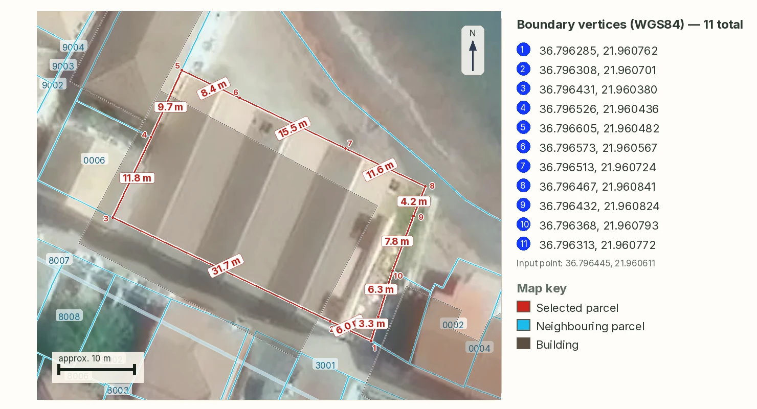
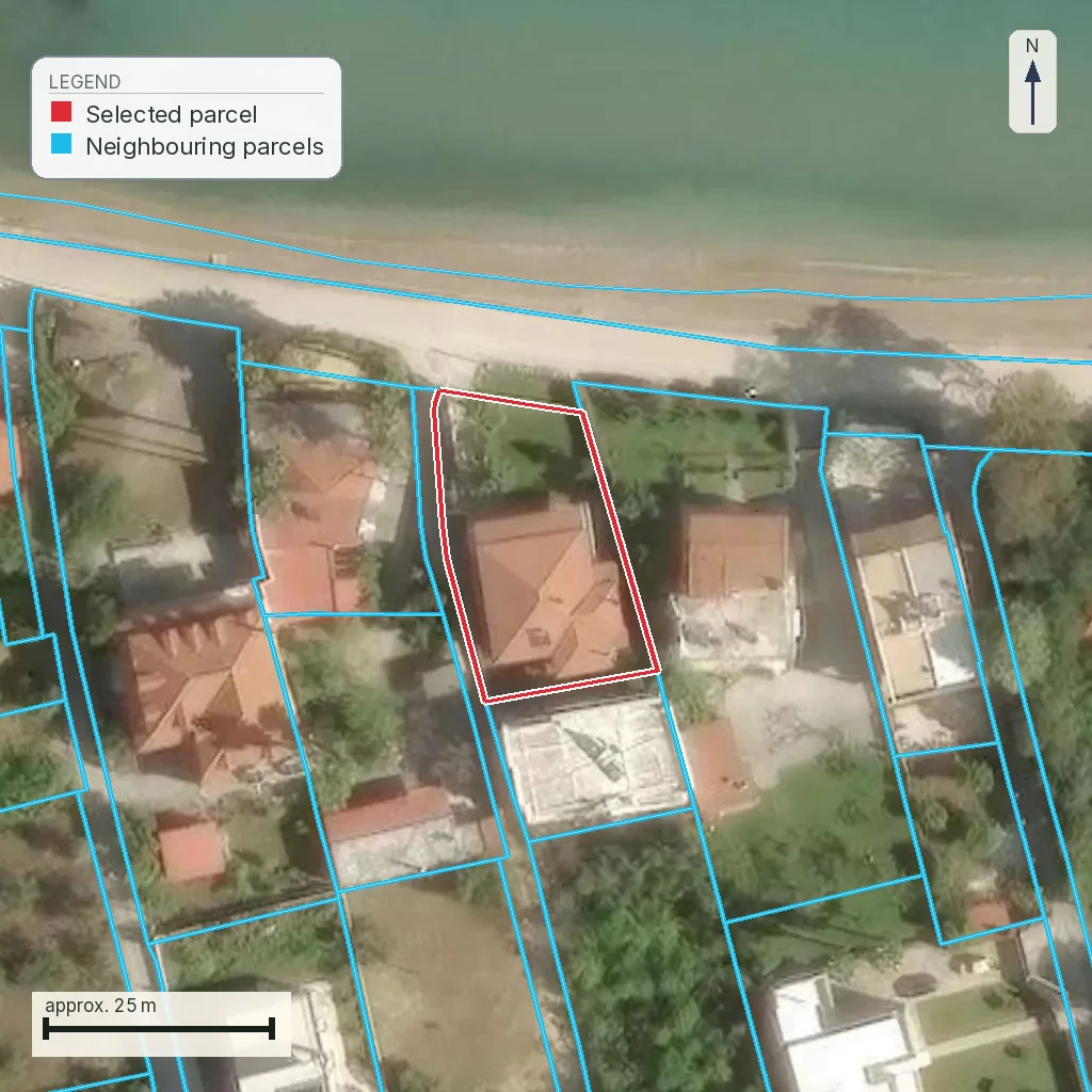
Take a real coastal plot in Messenia. The Hellenic Cadastre publishes it as KAEK 361230180008, and the operating cadastre's own polygon measures 779.65 m² over eleven vertices, with a perimeter of 116.2 m. The listing rounds this to 780 m². The edges run from 3.3 m at the shortest to 31.7 m at the longest, and a building footprint of roughly 737 m² reaches inside the boundary. The nearest road lies about 9 m from the limit and the mapped coastline about 12 m.
The first condition of the exemption is satisfied here: this is an operating cadastre, not an exhibition. What no register answers is where those eleven vertices fall on the ground, whether the wall a visitor sees follows the third edge or cuts two metres inside it, and whether the structure that occupies most of the plot sits within its permitted distances. On a plot this size, a two-metre discrepancy along the 31.7 m edge is about 8% of the land. That is the arithmetic behind the whole argument.
The same reading on Samos, one cadastral phase earlier
A second parcel makes the phase test concrete. Above Kokkari on Samos, a 1,084 m² plot with a 142.9 m perimeter is published through the cadastre's public-exhibition layer as KAEK 430170242246. Exhibition, or ανάρτηση, is the stage at which surveyed geometries are put in front of citizens for review before the cadastre for the area formally begins to operate. The outline is real official survey data and it is also provisional: both the boundary and the code can change while objections are heard.
For the exemption, that settles it. There is no λειτουργούν Κτηματολόγιο in this area yet, so the first condition fails and the plan stays compulsory whatever the second condition would have said. For the buyer it settles something larger. A boundary that the state itself describes as open to correction is the last boundary anyone should buy without a measured plan, and the exemption was never going to apply here anyway.
What to do if your transfer really is exempt
Suppose the notary confirms all three conditions and no plan has to be attached. The saving is real: a survey costs money and takes days that a transaction may not have. It is still worth commissioning one, and the reason is that the plan was never mainly a document for the registry. It was the buyer's only independent measurement of the thing being bought.
- Ask the notary, in writing, which of the three conditions the file relies on.
- Ask the registry or the planning office for the implementation act reference.
- Commission a measured plan in ΕΓΣΑ 87 anyway, with occupation drawn against the limit.
- Have the lawyer compare the plan, the cadastral sheet and the title before the deposit.
- Keep the plan. The next permit, the next sale and any dispute will ask for it.
Mark anything you could not obtain as requested, received, in conflict or unpublished, and leave it visible in the file. A missing implementation act is a fact about the area, and a seller who cannot produce one has told you something useful about which rule applies.
Where this page stops
This is a reading of a published statute and of two real parcels, prepared for buyers who are trying to work out whether a news headline applies to them. It is not legal advice, it does not tell you whether your own transfer qualifies, and it cannot confirm a boundary. The notary decides the first question, a surveying engineer answers the second, and both of them work from the file rather than from a page like this one.
LandCheck sits earlier than either. For one exact parcel it reads the cadastral geometry the register publishes, states which cadastral phase that geometry comes from, measures it against roads, coastline, forest and flood layers, dates every source and writes down the questions that only a professional can close. The report is a EUR 29 preflight from public data. What the lawyer, the engineer and the notary have to sign stays theirs to sign.
Common questions
Has Greece abolished the topographic diagram for property transfers?
No. Άρθρο 16 ν. 5293/2026 lifted the attachment duty of άρθρο 5 παρ. 1 ν. 651/1977 only where the area has an operating cadastre, a ratified and registered πράξη εφαρμογής, and the transaction leaves the boundary unchanged.
Since when does the exemption apply?
Since 7 April 2026, the day ν. 5293/2026 appeared in ΦΕΚ Α΄ 57.
Does it cover a plot outside the town plan?
In practice no. The exemption needs a πράξη εφαρμογής, which is an instrument of ν. 1337/1983 that exists only where a street plan has been implemented, and out-of-plan land has none.
What is a πράξη εφαρμογής in plain terms?
It is the act that puts a street plan into effect on the ground, fixing the land each owner surrenders, the money contribution owed, and the final position of plots and roads.
If a plan is not attached, does anyone still check the boundary before I sign?
Only if you commission the check. The attached plan was the point in the transaction where a licensed engineer compared the register with the ground and signed for the comparison.
Do I still need the electronic filing receipt from the cadastre?
Yes, whenever the deed uses a survey plan dated 16 July 2018 or later. Ν. 4409/2016 άρθρο 40 keeps that duty and the notary attaches the receipt on penalty of nullity.
My parcel is in the public-exhibition phase. What changes for me?
Nothing is relaxed. The area has no operating cadastre yet, so the first condition fails and the plan stays compulsory, while the published boundary itself can still be corrected.
Should I commission a survey even when the notary says none is required?
For most buyers yes. The saving is one professional fee, and the exposure is the boundary, the distances of any structure and any outstanding contribution under the plan.
Keep reading
How to read a τοπογραφικό διάγραμμα: the survey sheet, callout by callout
When a Greek deed and the cadastre disagree: who fixes the parcel?
ΚΑΕΚ and the Greek cadastre: reading the code, and the deadline behind it
Greek title deeds and boundaries: when words meet a coordinate polygon
Check this on your own parcel
Pin the plot, confirm the KAEK, and every check in this guide is read against it and written up with its source and date. EUR 29 total · VAT included.