
Διαβάστε το άρθρο στα ελληνικά.
Greek title deeds and boundaries: when words meet a coordinate polygon
On this page
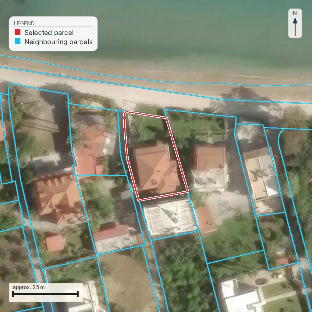
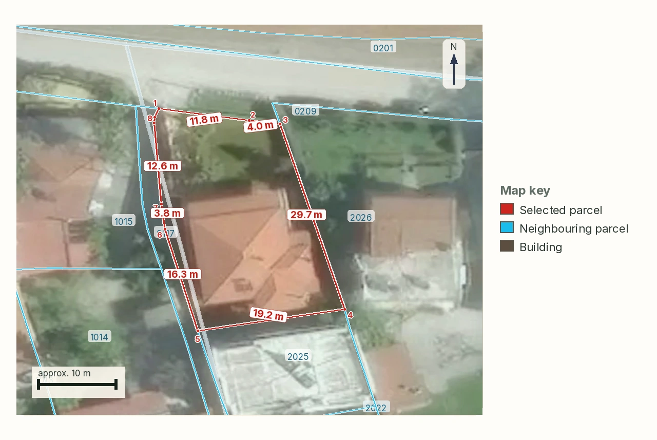
The Terpsithea parcel, KAEK 311500507001, is 56,923 m² with a 975 m perimeter. A deed may identify land through neighbours and landmarks, while the cadastre stores a coordinate polygon. The area sentence, an unwalked perimeter and one map probe cannot settle the boundary by themselves.
This guide is a preliminary screen for a purchase or permit question, not legal, surveying, engineering or tax advice; read the full scope and limits before relying on it.
Have a specific plot in mind? Every check in this guide can be run on it, with source and date, for EUR 29 total · VAT included. Pin it on the map →
A boundary in a deed is often a sentence: north by the land of a named neighbour, east by an old path, south by a stream, west by another owner. A cadastral system needs a polygon whose vertices can be compared with other polygons. The sentence and the polygon may identify the same land, but neither one should be promoted to ground truth without reconciliation.
The Terpsithea parcel makes the problem large enough to see. It has KAEK 311500507001, area 56,923 m² and a recorded perimeter of 975 m. The registry check read 56,922.96 m², `DESCR` Καλλιέργεια, operating stage, and a local first-registration deadline of 31 December 2033. The perimeter is a number in the file. That reading does not say that a person has walked all 975 metres and agreed each bend with the neighbours.
Read the topographic-diagram guide for the document obligations, and the KAEK guide for the register's identifier and object. Here the document is only the measuring language. The question is narrower: what does a title's boundary description amount to when the public record draws a coordinate polygon, and what does a buyer do when the two do not land on the same ground?
Three descriptions of one piece of ground
Keep these descriptions side by side and postpone any decision about which one carries the issue.
- The title sentence. It preserves the identity used by the parties, through neighbours, landmarks, local names and the area stated at the time.
- The cadastral polygon. It gives the public spatial object a KAEK and a geometry that can be placed beside other registered objects.
- The measured ground. It is what a current surveyor can test against coordinates, fences, paths, walls, cultivation and the descriptions carried by the deed chain.
A buyer needs all three because each can be incomplete in a different way. A neighbour may have changed name or divided the land. A landmark may have disappeared. A polygon can be at a provisional or inaccurate position. A fence can follow neither the title nor the register. The correct conclusion is not that a difference in words automatically defeats a title, or that a clean polygon automatically proves the seller's boundary.
The area is an attribute, not a complete boundary description. Two shapes can have the same area and different neighbours, frontage and position. Read the parcel's 56,923 m² with its perimeter and the line's coordinates; neither measurement replaces the other.
Terpsithea: the figure is useful, and still not enough
| Field read for the parcel | What the buyer can carry forward | What the field leaves unanswered |
|---|---|---|
| KAEK 311500507001 | A stable registry identifier for the Terpsithea object. | Whether every deed in the chain names that same physical object. |
| 56,922.96 m² in the registry check | The current service area, close to the rounded figure of 56,923 m². | Whether the deed's area was measured in the same way or describes the same boundary. |
| 975 m perimeter in the parcel's registry description | A warning about how many turns and adjoining relationships require checking. | Whether the ground has been walked, whether the perimeter is current, and where each corner lies. |
| Operating stage, deadline 31.12.2033 | The local cadastral context and the date to investigate before a challenge becomes late. | The legal effect of a particular deed, burden, neighbour claim or physical fence. |
The dated finding is therefore modest and valuable. On 1 August 2026, the registry service identified the parcel as 56,922.96 m² of cultivated land in an operating cadastral area. It did not read the deed, did not certify the 975 m perimeter on the ground, and did not decide whether the parcel is buildable or accessible. A buyer should want exactly that distinction in the file.
What a neighbour description actually carries
“North by the property of Α.” gives a relationship tied to the deed's context. To use it, the surveyor has to discover which property Α. meant in that deed, whether the name still identifies the same owner or parcel, and whether the adjoining description survives later divisions and transfers. “By the old road” has the same problem when the road has been widened, moved, renamed or become a track.
The deed chain matters because the first description may be clearer than the last one. One contract may name the former owner of a large holding. A later deed may describe a part by the new neighbours. A third may round the area and omit one side. Reading only the seller's last page can hide the point at which the identity changed.
This is also where rights beside the boundary become relevant. A δουλεία διόδου may provide passage over private land, but a private passage does not automatically create planning frontage. An εξ αδιαιρέτου share can be an ideal share in the whole and may not identify a separately located strip. Those are title questions attached to the boundary; the polygon's colour cannot answer them.
Ask the surveyor to write the reconciliation in words. Which deed neighbour is which KAEK? Which landmark still exists? Which side is a legal right of way and which side is only a route visible on the ground? A map that cannot answer those questions is a useful index; the identity check remains incomplete.
One probe is not an answer for a parcel
The reference case is KAEK 330566403009 in Mytilene, Lesbos, 3,911 m². On 1 August 2026, the live forest-map check returned ΠΑ at one sample point and ΑΑ at two others, because the mapped forest boundary runs through the parcel. The lesson concerns spatial sampling. This page does not become a forest-map article.
If a single click had been made at the PA point, a report could have printed a reassuring character while two other points sat in a different class. If the click had landed on AA, the opposite error would have been just as easy. Compare the polygon boundary with the parcel boundary, and treat the first response as one sample.
Apply the same discipline to a deed boundary. Sample points can test whether a polygon reaches the parcel, but they cannot tell the buyer which neighbour owns a corner, whether a line is a legal boundary, or which part of the land a historical deed intended. For the Terpsithea parcel, the 975 m perimeter makes a one-point answer especially implausible.
ΕΓΣΑ '87 is the common ruler
A coordinate polygon becomes useful for comparison only when the drawing and the cadastral geometry use the same reference system. Article 1 of Απόφαση 71154/4228/1995, ΦΕΚ Β΄ 639/19.7.1995, identifies the Greek Geodetic Reference System of 1987, ΕΓΣΑ '87, as the reference system of the National Cadastre.
The 2018 electronic-filing decision, ΥΑ ΥΠΕΝ/ΔΝΕΠ/27623/1752/2018, ΦΕΚ Β΄ 2216/14.6.2018, article 3 paragraph 2, says that diagrams submitted electronically by the engineer are εξαρτημένα from the state coordinate system ΕΓΣΑ '87. In plain terms, an εξαρτημένο survey has a reproducible tie to the state's reference. It can be laid over the cadastral polygon in a way another professional can inspect.
An unattached drawing may still contain careful local measurements. It does not, by that fact alone, settle a deed-versus-cadastre disagreement. If its origin, control or reference system cannot be stated, the buyer cannot tell whether a five-metre shift is a real boundary mismatch or a drawing that was never tied to the same ruler.
Coordinates computed for the guide's parcels (pyproj, EPSG:4326 → EPSG:2100) show example ΕΓΣΑ '87 values. They do not provide the deed coordinates or a surveyed boundary for this parcel. That gap is important. A coordinate table can demonstrate the language of comparison; it cannot manufacture a boundary that was never measured.
An electronic diagram leaves a ΚΗΔ trail
When a diagram is filed electronically, the document trail is more than the image attached to a deed. Article 40 of ν. 4409/2016 requires the electronic-submission proof to accompany the deed, with the statutory consequences of nullity or rejection set out in paragraphs 1 and 3. The filing route also covers a diagram of geometric changes, which matters when the cadastral polygon itself is the disputed object.
The code printed on that proof is the ΚΗΔ, the Κωδικός Ηλεκτρονικού Διαγράμματος. Article 3 paragraph 3 of the 2018 decision describes one code per submitted diagram and a certificate carrying the code, submission date, diagram image, property location, diagram details and engineer details. For a buyer, ask for the proof and its date, then give the code to the lawyer and surveyor with the deed chain.
The filing duty is recorded as applying to diagrams drawn from 16 July 2018. That date comes from professional guidance reported by the Hellenic Cadastre operator (ΕΚΧΑ), not from a fully opened public lookup page. The live Hellenic Cadastre service returned an access error on 1 August 2026, so this page does not promise that every buyer can retrieve a certificate without access conditions.
Source: Law 4409/2016 article 40 (ΦΕΚ Α΄ 136) and ΥΑ ΥΠΕΝ/ΔΝΕΠ/27623/1752/2018 article 3 paragraph 3 (ΦΕΚ Β΄ 2216/14.6.2018), checked 1 August 2026. Limitation: the live ΚΗΔ lookup service at ktimatologio.gr returned an access error on that date, so its public-access requirement was not confirmed; ask the notary or engineer to retrieve the certificate.
What the 2026 wording changes, and what it does not
The current codification places the sale-diagram rule in article 283 of ν. 5306/2026, ΦΕΚ Α΄ 88/8.6.2026, corresponding to article 5 of ν. 651/1977. Its text names side lengths, adjoining boundaries, known adjoining owners and the area, and asks the engineer to state whether building is allowed under the planning rules. That list describes what a transfer file may need. It does not make the area figure a substitute for the boundary, or the cadastral polygon a title opinion.
The same code places the engineer-certificate provisions in article 368, corresponding to article 83 of ν. 4495/2017. Article 368 paragraph 5(γ) also makes the out-of-plan, non-adequate and non-buildable exemption test the area according to the title. That is a warning against silently substituting a measured or cadastral area for the words in the deed. It is not a verdict that this parcel falls within that exemption.
The April 2026 change can remove the attachment obligation only when the cumulative conditions in article 283 are met: an operating Cadastre, a ratified and registered implementation act, and no boundary change in the transaction. This page does not use that exception to answer for this parcel. The question here is whether the boundary is the same, and that question remains even when a document is absent from a particular transaction.
The 2026 exception does not erase the out-of-plan check
The three conditions are cumulative, not three alternative reasons to omit the diagram. An operating Cadastre is only the first gate. The area must also have a ratified and registered πράξη εφαρμογής, and the transaction must leave the property boundaries unchanged. A listing that mentions only “Cadastre available” has not shown all three.
The implementation act (πράξη εφαρμογής) is an in-plan instrument. For out-of-plan land, condition two is therefore absent and this particular attachment exception cannot be used to skip the diagram. That does not answer whether this parcel is buildable, and it does not turn a missing diagram into proof that the deed and polygon coincide.
The April amendment also leaves the engineer certificate and the electronic filing obligations in their own provisions. Keep the boundary question alive even where a notary says that one attachment is not required for a particular transaction.
Source: Law 5293/2026 article 16 (ΦΕΚ Α΄ 57/7.4.2026) and law 5306/2026 article 283 paragraph 1 (ΦΕΚ Α΄ 88/8.6.2026), checked 1 August 2026. Limitation: the exemption was not found applied to this parcel in a public source on that date, and no planning-status conclusion is made here.
The engineer certificate has its own two-month clock
The 2026 code carries the engineer-certificate rule into article 368, corresponding to article 83 of ν. 4495/2017. Paragraph 6 gives the certificate a validity of two months from signature. If a purchase file drifts past that period, the buyer should ask whether the certificate is still current instead of assuming that an old signature covers a new deed.
The same provision contains an exemption for an out-of-plan property that is non-adequate and non-buildable according to the area stated in the title. “According to the title” is the important limiter: the cadastral area or a new survey cannot silently replace the deed's figure when the exemption is being considered. This page does not decide whether this parcel qualifies.
Article 368 also asks the diagram to state the method of connection and the state-system triangulation points used for it. Those details help a professional reproduce the comparison; they do not supply missing deed coordinates or certify the 975 m perimeter on the ground.
Source: Law 5306/2026 article 368 paragraphs 4, 5(γ) and 6 (ΦΕΚ Α΄ 88/8.6.2026), checked 1 August 2026. Limitation: no current engineer certificate or exemption assessment for this parcel was found in a public source on that date.
Build the boundary file from the inside out
Start with the deed chain and make a table of every identity clue. Copy the area exactly as written, preserve the old spelling of each neighbour, mark the landmarks, and note whether the description refers to a whole holding, an undivided share or a part that was cut from a larger property.
Then place the current KAEK and cadastral polygon beside it. The cadastre publishes 56,922.96 m²; this page did not read the deed, so it has no deed figure to compare. When both documents are available, place the exact deed area beside the cadastral area and test whether they describe the same boundary. Area is one test; overlap, corner positions, neighbours and access are other tests.
Finally, ask for an independent survey tied to ΕΓΣΑ '87. The surveyor should say what was actually checked, which boundary evidence was accepted, and where the deed remains ambiguous. If the proposed building or road uses only one corner, check that corner and its legal access, then inspect the parcel centroid as a separate point.
| Question in the file | Evidence that answers it | Person who should answer |
|---|---|---|
| Is this the same parcel through the deed chain? | Older and current deeds, names, landmarks and the cadastral identity. | Property lawyer with the surveyor. |
| Does the polygon fit the written neighbours? | Current KAEK geometry, adjoining KAEKs and a survey tied to ΕΓΣΑ '87. | Independent surveyor. |
| Does a passage create legal frontage? | The registered right, its act and the applicable planning rule. | Lawyer and planning professional. |
| Which line controls after a conflict? | The full legal file, the correction or judgment, and the current register. | Lawyer and competent authority, not a map click. |
The buyer's short decision
For the Terpsithea parcel, a large area is not the reassuring fact. It creates more boundary to identify. The 975 m perimeter means more opportunities for an old neighbour name, an unmarked corner, a displaced line or a claimed access route to matter. The operating-stage date is useful because it gives the buyer a local deadline to investigate. It does not certify the title boundary.
For Mytilene, the three forest responses show why a probe is not a polygon. The same reasoning applies here to the deed and cadastral geometry. The buyer should not accept “the point is inside” or “the map looks right” where the boundary itself is the purchase subject.
Proceed only when the lawyer can explain the deed chain, the surveyor can identify the same ground in ΕΓΣΑ '87, and the current register can be read with its date and stage. If one of those pieces is missing, record the boundary as unresolved and close that missing-data item before the deposit.
What the map does not confirm
The parcel's polygon can show the registry's spatial object, date and stage. It cannot confirm that the deed description refers to the same ground, that a fence sits on the legal boundary, that access is a registered right or that the property is buildable. Those questions need different evidence.
Use the map as the starting point for the file: the complete deed chain, current extract, an ΕΓΣΑ '87-dependent survey and a written reconciliation of the disputed points. If one is missing, the map proves what was published, not exactly which land is being bought.
Source: Law 5306/2026 articles 283 and 368 (ΦΕΚ Α΄ 88/8.6.2026) and the Ελληνικό Κτηματολόγιο parcel-service record for KAEK 311500507001, checked 1 August 2026. Limitation: no deed, walked boundary inspection or buildability result for this parcel was found in a public source on that date; ask a lawyer and a surveyor for them.
Scope of this page
This is a property preflight, not a survey, title opinion, boundary judgment, planning approval or proof of buildability. It does not decide whether this parcel's deed and polygon coincide. It shows why the area, perimeter, neighbour description, sampling point and coordinate reference must be read together by the professionals who can establish them.
Common questions
Does a deed boundary made from neighbours equal a cadastral polygon?
Not automatically. The deed gives relationships and landmarks, while the cadastre gives a spatial object. A surveyor must identify the deed neighbours and compare the same ground in a common coordinate system.
Is the area written in my deed the whole boundary?
No. Area is one attribute in a description. It does not identify each corner, adjoining owner, access relationship or the position of the shape. Read it with the deed words and a current survey.
Can one forest-map click represent my 56,923 m² parcel?
No. The Mytilene reference returned PA at one point and AA at two others because a mapped boundary crossed the parcel. A parcel-sized question needs the polygon and more than one observation where the line may enter it.
Why must a boundary survey use ΕΓΣΑ ’87?
The national cadastre uses ΕΓΣΑ ’87 as its reference system. Tying the survey to that same system gives the lawyer and surveyor a reproducible basis for overlaying the title-related evidence and the cadastral geometry.
What does εξαρτημένο mean on a Greek boundary survey?
It means the electronically submitted diagram is tied to the state coordinate system ΕΓΣΑ ’87 under the 2018 decision. It does not, by itself, prove that the deed description or the fence is correct.
Does a 975 m perimeter prove that someone checked the ground?
No. It is a perimeter figure recorded in the registry check. That figure does not establish a complete walked boundary inspection, so ask what was measured, when and against which evidence.
Who decides when my deed and cadastral boundary disagree?
The surveyor explains the physical and coordinate mismatch, the lawyer selects the title or procedural route, and the competent cadastral office or court decides within its authority. No single map click decides the purchase.
Does the April 2026 rule mean an out-of-plan property needs no topographic diagram?
No. The attachment exception requires an operating Cadastre, a ratified and registered implementation act, and no boundary change, all together. The implementation act is an in-plan instrument, so it does not create an exemption for this out-of-plan parcel.
Keep reading
How to read a τοπογραφικό διάγραμμα: the survey sheet, callout by callout
When a Greek deed and the cadastre disagree: who fixes the parcel?
ΚΑΕΚ and the Greek cadastre: reading the code, and the deadline behind it
Legal road access in Greece: what πρόσωπο σε κοινόχρηστη οδό means, and how a road becomes public
Check this on your own parcel
Pin the plot, confirm the KAEK, and every check in this guide is read against it and written up with its source and date. EUR 29 total · VAT included.