
Pillar: Ground, hazard and utilities
Διαβάστε το άρθρο στα ελληνικά.
Wells and Boreholes in Greece: Water Rights a Property Buyer Must Verify
On this page
A well on Greek land is not automatically a legal or transferable water supply. Ν. 3199/2003 fixes which uses need a permit; ΚΥΑ 145026/2014 fixes when a notary needs the ΕΜΣΥ certificate.
This guide is a preliminary screen for a cost or timing question, not legal, surveying, engineering or tax advice; read the full scope and limits before relying on it.
Have a specific plot in mind? Every check in this guide can be run on it, with source and date, for EUR 29 total · VAT included. Pin it on the map →
A well or a borehole on Greek land starts life as a physical claim. Whether it also stands as a legal water right depends on two national instruments that turn the claim into paperwork a notary will ask for: the 2003 water law fixes which uses need a permit and what a fine looks like when they run without one, and a 2014 register decides whether a deed can even be signed. Read this beside our topographic diagram guide and our buildability guide before pricing rural land with a claimed water supply.
What “has water” actually claims
The phrase “private well” in a listing is not one fact but four: that a physical point exists, that someone currently uses it, that some document exists for it, and that the document will follow the property at transfer. Wells, boreholes and springs are all treated as σημεία υδροληψίας — abstraction points — under Greek water law, and each one carries its own file whether it is fifty years old or was drilled last winter.
A buyer needs to separate the physical presence of water from its technical performance, its administrative status and its transferability. Those are four separate questions with four separate answers, and a photograph of a pump answers none of them.
Two instruments carry the weight of this guide, and both come up again and again in the sections below: ν. 3199/2003 for which uses need a permit at all, and ΚΥΑ οικ. 145026/2014 for when an ΕΜΣΥ record becomes a condition of the signature itself. Anything that does not rest on one of the two, or on a source that states it directly, is flagged here as unestablished.
Ν. 3199/2003: the law behind every water permit
Ν. 3199/2003 (“Protection and management of waters”, ΦΕΚ Α΄ 280/9.12.2003) is the base framework. Άρθρο 10 fixes five uses that need a water-use permit: ύδρευση, αγροτική χρήση, βιομηχανική χρήση, ενεργειακή χρήση and χρήση για αναψυχή. The rule covers surface and groundwater alike, both as simple abstraction and where abstraction runs through a water-development work.
Άρθρο 13 of the same law carries an administrative fine for abstracting without the permit a use requires. The floor is €1,000. No upper limit and no criminal limb were established for this page, so neither is stated here as a number.
Two different permits, one confused conversation
This is where most listings fall apart under questioning: ΚΥΑ οικ. 146896/2014 (ΦΕΚ Β΄ 2878/27.10.2014) separates the άδεια εκτέλεσης έργου αξιοποίησης υδατικών πόρων from the άδεια χρήσης νερού. The first allows drilling or building the works. The second allows abstracting and using the water, for a stated holder and use. They are two different documents from two different applications.
A borehole can stand lawfully as a work and carry no active use permit at all. A seller's “it's all in order” does not say which of the two permits they mean. Both are issued by the Διεύθυνση Υδάτων of the Αποκεντρωμένη Διοίκηση alone; neither the δήμος nor the ΥΔΟΜ issues either one. A change of use, holder or works runs through a separate τροποποίηση procedure. Confusing the two documents is the single most common reason a listing describes a borehole as “in order” while only one of the two permits actually holds.
ΕΜΣΥ: the national register, and what a code proves
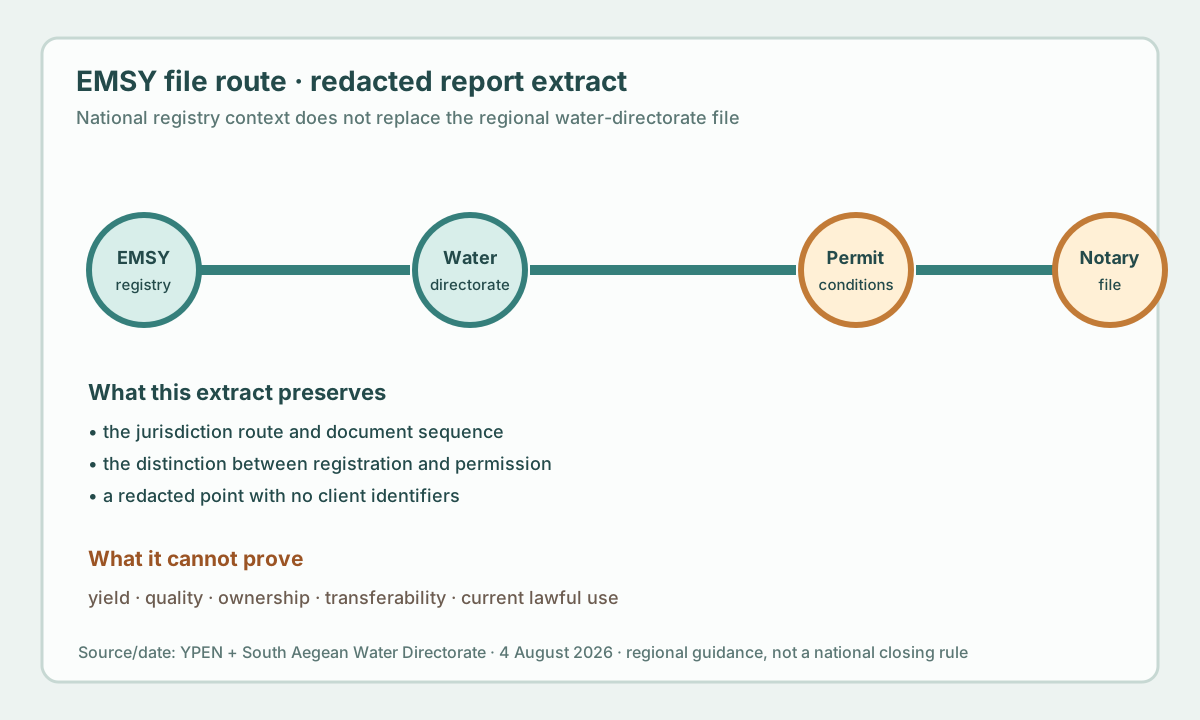
ΕΜΣΥ, the Εθνικό Μητρώο Σημείων Υδροληψίας, was set up by ΚΥΑ οικ. 145026/2014 (ΦΕΚ Β΄ 31/14.1.2014) as a geospatial database of abstraction points from surface and groundwater systems, mapped per river basin. Registration is applied for on Παράρτημα Ι of the same ΚΥΑ.
A registration code makes a point traceable in the administrative system. On its own it does not establish quantity, quality, current use or the right to abstract; the water-use permit is where those questions are actually decided. A regional certificate page belongs to its own jurisdiction: South Aegean guidance is not a universal national closing rule, and a notary confirms the live requirement for wherever the property actually sits.
Active or inactive: why a dry hole still needs paperwork
The duty to register in ΕΜΣΥ reaches active and inactive points alike. An old decorative well or a dry borehole is not exempt simply because it abstracts nothing today; its physical presence raises the same document question.
Ask the seller for a written statement of active or inactive status, and do not accept a verbal “it is not used any more, so it does not matter.” An inactive point that has never been registered stays an open item in the file until it is resolved.
The registration code and where it can live
The ΕΜΣΥ registration code can live in one of two places: on the registration certificate itself, or printed on the property's τοπογραφικό διάγραμμα. Where the water-use permit decision already carries the code, a separate ΕΜΣΥ certificate is not needed for the notarial act, the code recorded in that decision is enough. The τοπογραφικό route is something a buyer can ask their own engineer to do directly: mark the code on the survey while the certificate is still pending.
Read this beside our topographic diagram guide for what else the same drawing should show. A τοπογραφικό is more than a position drawing; it can also carry this one specific, legally useful fact.
Άρθρο 9 παράγραφος 2: the rule that reaches the notary
Άρθρο 9 παρ. 2 ΚΥΑ οικ. 145026/2014, in the 2014 text, requires, for a property carrying an abstraction point, the ΕΜΣΥ registration certificate or the registration code on the τοπογραφικό διάγραμμα, before a deed of transfer, gift, parental grant, inheritance acceptance or the creation of a real right is drawn up. Circular 9η/17-1-2014 of the Συντονιστική Επιτροπή Συμβολαιογραφικών Συλλόγων Ελλάδος (Σ.Ε.Σ.Σ.Ε.) records the rule in those same terms; the retrievable copy is published by the Thessaloniki Bar of Notaries, which hosts it without having issued it.
The same article has since been amended by ΦΕΚ Β΄ 1212/10.7.2015 and clarified again by a 2021 Συντονιστική circular. What changed was not read for this page, so treat the rule above as the 2014 text and ask your own lawyer for the wording now in force. It covers a purchase, a gift, a parental grant, an inheritance and the creation of a right regardless, and a buyer whose plot has an abstraction point meets it at the notary's desk, in a real transaction.
Worked example: a Thessaly plot and a search we did not run
One of the standing parcels this guide draws on sits at Τερψιθέα, near Λάρισα: 5.7 hectares of flat agricultural land with no road touching its boundary, inside the country's largest plain. Agricultural irrigation from boreholes is routine there, and closely watched at the same time, because Thessaly carries some of the country's heaviest water stress.
No live ΕΜΣΥ or Διεύθυνση Υδάτων search was run for this specific plot while writing this page. No live search exists for any one plot in the first place: neither register can be queried by parcel from outside, and only a paid LandCheck order or the buyer's own written request to the Διεύθυνση Υδάτων produces a dated result for one exact point. That is the honest answer: we do not know whether this field carries a registered abstraction point, and no one should assume either way without their own application to the Thessaly Water Directorate.
A genuine LandCheck order for this same parcel would query the public layers on the day of the order and print a dated result, positive or negative, with the source named beside it. This guide maps the questions that order, a lawyer and the Διεύθυνση Υδάτων then answer, one after another.
Coordinates, equipment and the boundary
ΕΜΣΥ coordinates need to be checked against the position on the τοπογραφικό, against where the physical equipment actually stands, and against the title boundary. A borehole on a neighbouring parcel, on shared land or on an old irrigation route raises a completely different question from one inside the property's own boundary.
Record who has access to the equipment, who pays for the electricity, and whether any agreement lets a pipe cross land that belongs to someone else. A lawyer checks those against the title, and a surveyor checks the position; the register checks neither one.
A simple site visit helps more than it looks: measure the borehole's distance from the nearest boundary with an ordinary tape and compare it against the τοπογραφικό. A gap of a few metres can mean the point does not even sit where the drawing shows it.
Yield, quality and the seasons a registry cannot see
A registered point can still have a variable yield, a seasonal drop, a failed pump, salinity, or simply not enough water for the house, pool or crop a buyer plans. The public register is not a flow test and not a quality analysis.
Ask for a recent technical measurement from a water professional, dated, with a stated method and the use it was tested against. An old verbal “there has always been water” is not a technical finding, even when a neighbour who has lived there for decades is the one repeating it.
Who checks what: lawyer, surveyor, water professional
Three professionals read three different pieces of the same file, and none of them covers the other two. The lawyer checks title, encumbrances, easements and whether ΚΥΑ 145026/2014 requires an ΕΜΣΥ certificate for this specific deed. The surveyor checks position, boundaries and whether the registration code has actually been marked on the τοπογραφικό διάγραμμα.
The water professional checks yield, quality, equipment condition and whether the current water-use permit matches the buyer's planned use. The notary, finally, judges whether the file is complete enough to draw up the deed under άρθρο 9 παρ. 2 of the ΚΥΑ. Ask for all four opinions in writing, dated, before a buyer commits a deposit. A foreign buyer gains from letting them speak directly to each other, beyond the buyer's own representative.
Water-file evidence matrix
| Check | Shows | Does not prove | Next step |
|---|---|---|---|
| Physical point | a well, borehole or spring exists on the ground | any legal or usable water | match it to the survey and the register |
| ΕΜΣΥ registration | the point carries a registration code | a right to abstract, or a stated yield | get the certificate, or the code on the τοπογραφικό |
| Drilling permit | the works were built as an authorised project | that the water use is currently permitted | ask for the separate water-use permit |
| Water-use permit | abstraction is authorised now, for a stated user and use | that the works permit or the deed file are also in order | read user, use, quantity and term on the document itself |
What happens while the file stays incomplete
Three concrete consequences follow an incomplete water file. The notary does not draw up the deed without the άρθρο 9 παρ. 2 evidence, so the signing simply stalls. Abstracting without the permit a use requires exposes whoever holds the point, new owner or old, to the fine under άρθρο 13 ν. 3199/2003, with a floor of €1,000.
And the irrigation or domestic supply a buyer planned around the point stays unresolved until the use permit is located or a fresh application is filed, which can cost an entire growing season. None of the three is fixed by a sentence in the contract; it is fixed only by the actual document in hand, and the earlier a buyer asks for it, the less the delay ends up costing them.
Before money changes hands
| Field | Question | Evidence |
|---|---|---|
| Point | Where exactly does it sit against the boundary? | Coordinates and the τοπογραφικό διάγραμμα |
| Use | What does the water-use permit actually authorise? | The ΚΥΑ 146896/2014 permit, read in full |
| Deed | Does this property need the ΕΜΣΥ certificate at signing? | The άρθρο 9 παρ. 2 ΚΥΑ 145026/2014 test |
Ask for the ΕΜΣΥ code or certificate, the water-use permit with its terms, user and equipment details, a recent technical measurement where one matters, and any document that names the point in a prior deed. Ask for a source and a date behind every number, always in writing. A verbal assurance replaces none of that.
The sequence that protects the buyer
The order matters as much as the steps themselves. A buyer who requests the technical yield measurement first and only then goes looking for the use permit has already spent time and money on a point that may turn out to carry no lawful basis at all. The sequence below always starts with the file and only then moves to the technical test.
- Record the physical point and the property polygon.
- Request the ΕΜΣΥ code or certificate and the current water-use permit.
- Match coordinates, user and equipment against the τοπογραφικό.
- Classify the point as active or inactive, with a written statement from the seller.
- Ask the Διεύθυνση Υδάτων of the competent Αποκεντρωμένη Διοίκηση for the live stage.
- Obtain a technical measurement of yield and, where relevant, quality.
- Make any open item a written condition before a deposit.
Questions to put in writing
These questions do not all belong in the same meeting. The first two go to the Διεύθυνση Υδάτων, the next three go to the surveyor, the notary and the water professional, and the last one comes back to the buyer, as a term of their own offer.
- Which Διεύθυνση Υδάτων has jurisdiction over this property?
- What use and quantity does the current permit actually cover?
- Do the point, user and boundary match the τοπογραφικό?
- Does this property need the ΕΜΣΥ certificate for this specific deed?
- Which yield or quality measurement is recent and fit for purpose?
- Which item becomes a deposit condition if something is missing?
What this preflight does not confirm
LandCheck records public water-related signals, source dates, geometry and the missing administrative or professional evidence. It does not confirm a water right, yield, quality, permit, ownership, title or legal buildability, and it does not replace legal, surveying, engineering or hydrogeological advice. “Document required” is a valid buyer result; reassuring wording is not a substitute for the competent file.
The same limit applies to this guide itself. The sources, the ΚΥΑ and the circulars named here were read on the dates printed beside them; they do not stand in for the live text a buyer's lawyer reads on the day of the transaction, and they do not stand in for the ruling on the actual file that only the competent Διεύθυνση Υδάτων can give.
Common questions
Does registering a point in ΕΜΣΥ make it legal?
No. Registration under ΚΥΑ 145026/2014 and the water-use permit under ΚΥΑ 146896/2014 are two separate files; a registered point can still be missing a current use permit.
Is a permit to drill the same as a permit to use the water?
No. ΚΥΑ 146896/2014 issues them as two different applications, so a lawfully built borehole can still have no active water-use permit.
Does every plot with a well need the ΕΜΣΥ certificate at the notary?
Only a plot carrying an abstraction point. Άρθρο 9 παρ. 2 ΚΥΑ 145026/2014 names transfer, gift, parental grant, inheritance acceptance and the creation of a real right.
Can the τοπογραφικό stand in for the certificate?
Yes, where the registration code already appears on it. That is the second route the same paragraph allows, alongside the certificate itself.
Who actually issues the certificate?
The Διεύθυνση Υδάτων of the competent Αποκεντρωμένη Διοίκηση, after an application filed through the owner's δήμος — not the δήμος itself and not the ΥΔΟΜ.
What is the fine for abstracting water without the permit it needs?
Άρθρο 13 ν. 3199/2003 sets a floor of €1,000. This research did not establish an upper limit, and none should be assumed.
How long does a water-use permit last?
ΚΥΑ 146896/2014 fixes a term, but its length, fee and processing time were not established by this research; ask the Διεύθυνση Υδάτων issuing the permit.
When should a buyer recheck the point, the registration and the permit?
Before a deposit and again before signing, and a second time if the point, the user, the permit or the intended use changes in between.
Keep reading
Septic tank or sewer in Greece: the wastewater question before buying
What makes a Greek plot buildable: άρτιο, οικοδομήσιμο and the 4,000 m² rule
How to read a τοπογραφικό διάγραμμα: the survey sheet, callout by callout
Buying land in Greece: the pre-purchase checklist, in the order the payments fall
Check this on your own parcel
Pin the plot, confirm the KAEK, and every check in this guide is read against it and written up with its source and date. EUR 29 total · VAT included.